Imagine what it would be like if every car in Canada were to careen uncontrollably down a mountain, through a narrow corridor and into the ocean.
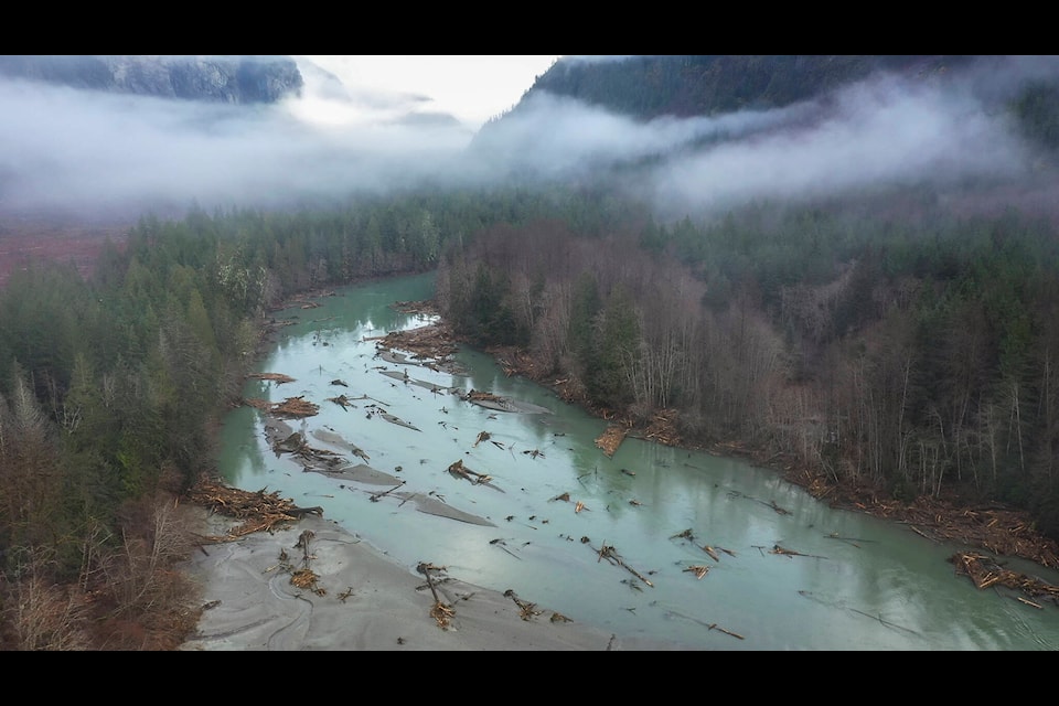
That���߲��о���s approximately what the mass of rock that fell into Elliot Lake, turning a small creek above Bute Inlet into a raging torrent, equated to, according to a new report from researchers on the November 2020 Bute Inlet landslide. According to the paper, roughly 18 million cubic metres of rock descended 1,000 metres into a glacial lake at the head of Elliot Creek in the traditional territory of the Homalco First Nation north of Campbell River on the B.C. mainland coast. The landslide had a mass of 50 million tonnes ���߲��о��� equal to the combined mass of every car in the country ���߲��о��� and caused a 100 metre Tsunami in a small lake, and sent pretty much everything down the valley to the ocean.
���߲��о���We expect large events to happen from time to time in areas like that. What���߲��о���s a little bit unusual though, is the magnitude of the wave. We have seen it in other places too, but I think this is the largest wave we���߲��о���ve seen in B.C. We haven���߲��о���t witnessed or seen the effects of anything that has been more than 100 metres high,���߲��о��� said Marten Geertsema, a researcher with the Ministry of Forests. ���߲��о���What���߲��о���s really remarkable is if you think about that small valley, you wouldn���߲��о���t be able to outrun this. We lost four million cubic metres of material in that creek in about ten minutes. It eroded to a depth of about 50 metres below the creek bed in a few places. It���߲��о���s hard to imagine that water power.���߲��о���
Researchers were quick to head into the valley and collect as much data as possible. Over the past year, they have been compiling and analyzing that data and have recently published their findings.
RELATED:
Part of Geertsema���߲��о���s research is the effects of climate change on natural hazards. Some of the modelling data presented in the paper can be used to help people prepare for the effects of climate change, particularly as rock slides and rock avalanches tend to increase in the mountains as the glaciers that had formerly held the rocks in place melt away.
���߲��о���We see an increase in rock slides in mountain areas, mainly in under two situations. One is when glaciers are receding, so they���߲��о���re often on the walls above those glaciers or in the area of those glaciers. The other area is where we have mountain permafrost degradation,���߲��о��� Geerstema said. ���߲��о���We���߲��о���re doing research in that area right now. We���߲��о���re exploring, especially these areas where we think landslides could be more likely to increase ���߲��о��� along the glacier margins. We���߲��о���re looking for these kinds of deformations that may give us an indication that slopes may be ready to fail.���߲��о���
As glaciers melt, they reveal lakes like Elliot Lake that were once hidden beneath ice. The report shows evidence of a similar rockfall in the same area, but since the lake was covered by the glacier at the time there was no catastrophic outburst flood.
���߲��о���An older landslide scar that is visible in aerial photography reveals that a landslide occurred from the same location before the 1950s,���߲��о��� the report says. ���߲��о���The older landslide likely ran across the glacier before Elliot Lake formed and thus the catastrophic flood experienced during the recent event could not have occurred.���߲��о���
Over the past hundred years, over 1,000 similar glacial lake outbursts have been recorded around the world, and over 12,500 people have died as a result. In 2017, an outburst flood in Greenland killed four and washed away most of the fishing village of Nuugaatsiaq.
In Canada, most of the events have been in remote areas that have not caused any injury to people, however, the researchers note that ���߲��о���there is no assurance that this will be true in the future, given increased development and tourism in these formerly remote areas.���߲��о���
LiDAR data compiled by the Hakai Institute has allowed researchers to do modelling of the slopes, which can be used to indicate dangerous areas in the mountains.
���߲��о���It was really fortunate that we got LiDAR from before the event and then after,���߲��о��� Geertsema said. ���߲��о���That LiDAR was provided by the Hakai Institute, so we���߲��о���re pretty grateful to them.���߲��о���
The Southern Coast Mountains of Western Canada has over 8,000 square kilometres of glacier-covered terrain, and it is seeing some of the fastest glacial loss rates in the world.
VIDEO:


